Mapping Future Elections
- Livable El Cerrito
- 2 days ago
- 6 min read

Renters and hillside residents were the most-discussed “communities of interest” at a June 16 public hearing on how best to divide the city of El Cerrito into five new City Council districts. The council agreed on two preferred maps with the goal of receiving more input from the public before choosing a final map on July 7.
Timeline for the Transition
The process is moving swiftly because of threatened lawsuit under the California Voting Rights Act (CVRA), which City Attorney Sky Woodruff has advised could be very costly. If the city acts quickly to draw districts, it can limit its potential legal costs. District voting will not be used in an election until November 2028, Woodruff said.
To comply with the CVRA and avoid what’s known as Racially Polarized Voting, the main goal is to draw fair and equitable districts that prevent the voting power of any group from being “diluted.” Instead, such voters can be grouped together to strengthen their power.
The Power of Renters
At the June 16 hearing, it appeared that renters will gain new recognition when the maps are drawn.
Both maps chosen this week contain two districts with a high proportion of renters. When renters were initially mentioned as a “community of interest,” several maps showed one long skinny district along the San Pablo Avenue corridor, where many renters live.
At the latest hearing, the city’s consultant Paul Mitchell of Redistricting Partners said the number of renters in the city requires that there be two districts with a relatively high number of renters.
Mapping a “Hillside/High Fire Danger” Area
Discussion also focused on what was called the “Hillside” area. This community of interest was submitted by a community member who called it “Hills/High Fire Danger” and said it includes “homes that have fire danger because they are in the hills and near or adjacent to Wildcat Canyon Regional Park and the Hillside Natural Area.” The person added, “This community of interest has a need for strong fire and emergency response.”
Council Members’ Views
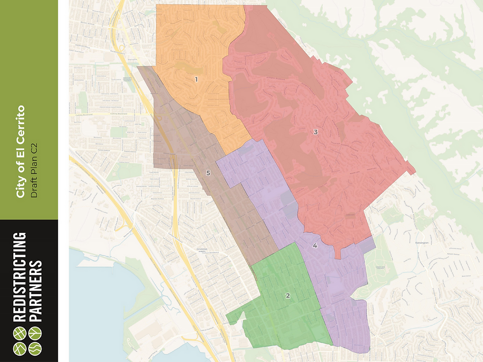
One of the maps chosen by the council, Map C2, includes an eastern hills district that covers a large area within the city. Mayor Gabe Quinto objected to Map C2, saying its use would cause the large hillside district to be labeled as the city’s high fire danger neighborhood.
Council member William Ktsanes said he liked Map C2 because it keeps more of the hillside area together.
Mayor Pro Tem Rebecca Saltzman said when she looked at Map C2, she saw at least three districts that have “a real interest in fire danger, including the one you talked about but also one in the hills and one right next to the hills.”
Saltzman continued, “And the reality that we’ve seen in California over the past few years is if a wildfire sparks in the hills we’re all in trouble…We’re not that big of a city so our entire city should care about fire danger. I think fire will continue to get attention almost no matter how we draw these districts.”
Keeping ‘Hillside Community of Interest’ Together
Mitchell, the consultant who will write the report justifying the way in which districts are drawn, said, “Now that this community of interest has been defined – even if it doesn’t align exactly with, for example, the (CalFire) high fire severity zone map -- if it’s divided there needs to be a justification for it.”
Other Maps That Were Viewed
Before agreeing on the A2 and C2 maps as their preferred choices, council members looked at many other maps, including Map B drawn by the demographer and Map 109, drawn by El Cerrito resident Neil Tsutsui, who joined on Zoom to explain the strengths of his map.

Seven people spoke in person at the June 16 public hearing.
Richard Brooks
Resident Richard Brooks said the city’s inaction with regard to the CVRA made it vulnerable to a threatened legal action.
“The CVRA passed in 2001,” Brooks said. “We’ve had over ten years of the 2016 Safe Harbor Act to get our act together and minimize our risk and exposure to this.”
Michael Coan
Resident Michael Coan said it’s about 2.7 miles from one end of San Pablo Avenue to the other in El Cerrito. “That to me would be a ridiculously long skinny district. I like the idea of making it north and south and making it into two districts.”
Coan asked whether a recent U.S. Supreme Court decision (which struck down Louisiana’s congressional map as a racial gerrymander) might affect the CVRA.
Coan said he looked up statistics on voter turnout and saw that precincts along San Pablo Avenue have had lower voter turnouts than other parts of the city.
Ideal Population is 5,200 Per District
Mitchell had explained earlier that districts need to be equal in population. A criterion is that the largest district is no more than 10% greater than the smallest, he said.
El Cerrito’s population is 26,000, so each district ideally will have 5,200 people.
Sally Goodman
Resident Sally Goodman said it’s important to make clear that the districts are based on population, not voting age population. She said she worked on civil rights compliance before retiring.
“The CVRA is intended to protect communities on the basis of race, color, language ability…and yet there’s no mention of this on the district website.”
Goodman continued, “There’s a huge emphasis on communities of interest. While I can appreciate the idea that you might think of renters as a proxy for communities of color, we’d need to look at data and have some evidence that that’s true – although I imagine it is probably true.”
Chelsea Sparti
Resident Chelsea Sparti said that “contrary to the maps we’ve been shown, all districts should …be diverse and integrated.” I believe that any map where the El Cerrito Hills are separate on their own is problematic and it violates that value of diversity.”
Grant Ricketts
Grant Ricketts said he’s not sure whether voting by district will be an improvement.
“Does that separate people more than integrate and work together across boundaries?” he asked.
Ricketts said an unnamed individual should not be able to force the transition without even proving what specifically is wrong with the way elections are conducted. He suggested that the city “play cat and mouse” with the plaintiff, testing whether a lawsuit would really be filed and trying to get a better explanation of why the complaint was filed.
Jerry Figone
Jerry Figone said he thinks the hills neighborhoods will have good representation. “Having two votes along the San Pablo corridor is important to me and I think it’s important to the city.”
Neil Tsutsui and Map 109

Neil Tsutsui, who is president of the El Cerrito Democratic Club but was acting as a resident, urged the council to choose Map 109, which he drew.
“I drew it to try to encapsulate some communities of interest,” he said. These include several populations with high concentrations of renters including along San Pablo Avenue, around Del Norte BART, around Plaza BART, and around one other high-density housing area. It includes communities of interest concerned about high fire danger in three districts.
Mitchell said one of the challenges of Map 109 was that “it put the renters in four different districts…That might be a challenge to justify,” Mitchell said.
“The state law says that we’re supposed to identify communities of interest and draw them into single districts so that they can have greater representative and voting power,” Mitchell said.
Sequence of Future Council Elections
Attending on Zoom, Ira Sharenow asked if there is a way to look at online maps and see which district one is in.
He also asked about the sequence of City Council elections and how things will work for whichever council members are elected by district in November 2028.
City Attorney Sky Woodruff said the council still needs to decide which districts will elect council members in 2028 and which will be elected in 2030. This decision will need to be made as part of the ordinance the council must pass no later than July 21, he said.
Public Input So Far
Since receiving a letter threatening a lawsuit on March 19, the city has held four public hearings and several community workshops. It announced that people could use an on-line app to draw their own maps online. It also invited people to submit “community of interest’ forms if they belonged to a group that should get consideration when boundaries were drawn.
The website shows 12 people submitted forms naming communities of interest.
Groups included people on fixed incomes, long-time residents, a part of North El Cerrito above Del Norte BART, an “outer north” neighborhood “from East Richmond Heights to a bit past Canyon Trail and down to San Pablo,” families in Kensington Hilltop Elementary School zone, new homeowners, bike riders, neighborhood west of the 80 freeway, and flat parts of El Cerrito.
The city’s website is <http://elcerrito.gov/districts>.


Comments